
Ogallala Aquifer
The Ogallala Aquifer extends from the northern United States into the Texas Panhandle and West Texas and is the primary source of water within the District
Request a presentation about the Ogallalla Aquifer and surrounding water resources
Contact us if you would like to request a presentation about the Ogallalla Aquifer and surrounding water resources from the North Plains Groundwater Conservation District? We would love to visit with you!
The District offers educational presentations and activities for all ages with topics ranging from water conservation to water-wise gardening and more.
Please contact Baylee Barnes at 806-935-6401 or bbarnes@northplainsgcd.org for more information.
Additional information about the Ogallala Aquifer can also be found at http://ogallala.tamu.edu/.
Summary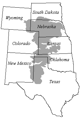
The Ogallala aquifer extends from the northern United States into the Texas Panhandle and West Texas and is the primary source of water within the District. The aquifer consists of sands, gravel, silts, and clay sediments that were deposited as part of ancient river systems approximately three to six million years ago during the Neogene geologic time period. An ancient land surface separates the Ogallala formation from much older strata below the Permian, Triassic, Jurassic, and Cretaceous geologic periods which range in age from 65 to 286 million years. This ancient land surface is called an unconformity and represents between six to 65 million years of missing geologic strata in the area. South of the District, the Canadian River has partially or totally eroded through the Ogallala formation along much of its length and separates the North Plains from the South Plains. Water bearing units of Cretaceous and Jurassic ages combine to form the Rita Blanca (a minor aquifer) in the western part of Dallam and Hartley counties. Underlying these aquifers and much of the Ogallala are Triassic (Dockum aquifer) sediments and Red Bed strata. Within the District area the Dockum is a minor, confined to semi-confined, aquifer and the water bearing strata is generally referred to locally as the Santa Rosa. For the purpose of this document, the Ogallala Aquifer will be considered to consist of the Ogallala formation and any underlying, potable water-bearing geologic units hydraulically connected with it.
Origin of the Ogallala
The Ogallala formation in Texas is the southernmost extension of the major water-bearing unit underlying the physiographic province of North America. It was named in 1898 by N.H. Darton for the town of Ogallala, Nebraska, near where the formation was discovered.
Following the Laramide revolution in which the southern Rocky Mountains were uplifted and the Cretaceous seas retreated, rivers flowing east and southeastward cut valleys into the pre-Ogallala surface. The deposition of the Ogallala formation began in late Miocene to early Pliocene age and continued until late Pliocene time when the climate became more arid and up-warping of the High Plains area caused deposition to cease and erosion to begin. During the Pliocene time, large quantities of eroded material from the Rocky Mountain region were transported by wind and water southeastward and deposited on the then existing surface of primarily Triassic and Permian age rocks. In certain areas, the depositional surface was composed of Cretaceous and Jurassic age sediments. The low valley areas were usually filled first by coarser materials such as gravels and coarse sand. As the valleys and basins filled, sediments overflowed to form coalescing aprons fed by braided streams that spread across a generally level plain. Eventually, the entire area was covered by Ogallala sediments until a maximum thickness of almost 900 feet was attained in southwestern Ochiltree County.
Throughout the time when the Ogallala sediments were being deposited, the southern Rocky Mountains remained tectonically active, providing source material for the Ogallala Formation.
Geology
The Ogallala formation unconformably overlies Permian, Triassic, Jurassic and Cretaceous strata and consists primarily of heterogeneous sequences of coarse-grained sand and gravel in the lower part grading upward into fine clay, silt, and sand. Gravel commonly occurs in layers in the basal section and ranges in size from boulders to pea size. In places, the Ogallala formation contains some quartz gravel and caliche with pebbles and cobbles of quartz, quartzite and chert being common. In the northern High Plains the formation has been divided into three subdivisions: the Valentine, Ash Hollow and Kimball, based on fossil vertebrates and flora. The subdivisions, often referred to as floral zones, are less distinguishable in the southern High Plains.
The sands are generally tan, yellow or reddish brown, medium to coarse-grained, moderately to well sorted, unconsolidated quartz grains, interbedded with thin layers of clay and occasionally sandstone. The sand is generally poorly consolidated to unconsolidated, although local cementation by calcium carbonate and silica occurs. Grain size and condition of sorting is an indication of the high energy involved in the depositional process of these sediments. As expected, sand grain and gravel size decreases and sorting improves eastward.
The gravel is usually associated with sand, silt and clay and is occasionally cemented. Quartzite is generally the predominant rock type in the gravel, although a high percentage of limestone boulders and cobbles occur in the southern area along with weathered Cretaceous invertebrate fossils. The occurrence of limestone gravel and Cretaceous fossils indicate that a local source possibly contributed to the Ogallala sediments in the southern third of the area.
Sedimentation
Near the surface of much of the Texas High Plains are layers of resistant caliche known as “caprock”. Caliche occurs in both Ogallala and post-Ogallala sediments and is formed by the leaching of carbonate and silica from surface soils and the re-deposition of the dissolved mineral layers below the surface. Although caliche layers occur primarily near the surface, deeper zones of caliche are also present. These deeper layers represent older soil horizons. The caliche ranges from crumbly to very hard and is almost impermeable although secondary porosity has been observed in many samples.
Previously, the Ogallala was described as fluvial sediments deposited as a series of coalescing alluvial fans or plains with only minor amounts of eolian sediments. However, Reeves, Hawley and others recognize the Ogallala as predominately eolian sediments in parts of Texas and southeastern New Mexico. Outcrop and core studies by Gustavson and Winkler indicate the Ogallala in Texas and New Mexico consists of alluvial sediments that partly fill paleovalleys and widespread thick eolian sediments capping paleo-uplands and most fluvial sections. Calcic paleo-soils and fossil evidence suggest a depositional environment in a mostly semiarid to sub-humid climate.
Hydrology and Orientation
Water-bearing areas of the Ogallala formation are hydraulically connected except where the Canadian River has partially or totally eroded through the formation to separate the North and South Plains. Water-bearing units of Cretaceous and Jurassic ages combine to form the Rita Blanca aquifer in the western part of Dallam and Hartley counties. Lower Cretaceous units form two separate subcrops within the Texas High Plains, the Edwards-Trinity (High Plains) and the Edwards-Trinity (Plateau). Underlying these three aquifers and much of the Ogallala are Triassic (Dockum aquifer) and Permian formations.
Thickness of the Ogallala formation is primarily controlled by the morphology of the eroded pre-Ogallala surface. The greatest thickness occurs where sediments have filled previously eroded drainage channels. These channels generally trend east or southeast. Other areas of large Ogallala thickness occur in the northeast quadrant of the Texas High Plains where sediments have filled collapsed basins formed by dissolution of Permian evaporites.
The saturated thickness of the Ogallala formation ranges from a few feet to more than 525 feet. In general, the areas of greatest saturated thickness occur in the North Plains. In the South Plains, between Lubbock and Midland, the saturated zone varies from less than 50 feet to 200 feet. Depth to water below the land surface can range from almost 400 feet in parts of the North Plains to between 100 to 200 feet throughout much of the South Plains.
Groundwater
Ogallala groundwater is generally fresh, containing between 300 and 1,000 milligrams per liter of dissolved solids of which calcium, magnesium and bicarbonate are the principal constituents. Some hydraulic continuity occurs between the Ogallala formation and the underlying Cretaceous, Triassic and Permian formations in many areas of the High Plains. For the purposes of this document, the Ogallala aquifer will be considered to consist of the saturated sediments of the Ogallala formation and any underlying, potable water-bearing units hydraulically connected with it.
Post-Ogallala Depositions
Post-Ogallala sediments consist of windblown sand and silt, alluvium, and playa lake deposits. Windblown sands occupy the largest surface area of the High Plains of Texas and are of both Pleistocene and recent (Holocene) age. They are primarily fine-grained to silty, sometimes calcareous and are derived from lacustrine, fluvial and eolian deposits. These sands and soils form sheet or cover sand, dunes and dune ridges with thicknesses generally ranging from 0 to 10 feet.
Alluvium is present as fluvial flood plain and terraced sediments along the more active streams and rivers. The deposits consist of poorly sorted, often cross-bedded, gravel sand and silt.
Lacustrine deposits, consisting primarily of clay and silt, line the bottom of the many playa lakes on the High Plains. The sediments are virtually impermeable, thus restricting natural recharge to the underlying formation.
Current Volume in Storage
The saturated thickness of the Ogallala aquifer in the North Plains Groundwater Conservation District ranges from 10 to over 460 feet with an estimated District average of 180 feet. The depth from land surface to the base of the aquifer can range from the land surface to as much as 1000 feet below surface. The depth to static water level from land surface can range from the land surface to in excess of 500 feet. Based on saturated thickness mapping and groundwater production reporting in 2006, the District estimates the usable quantity of groundwater within the District was in excess of 133 million acre-feet in 2006.
The year 2000 volume in storage is taken from Table One of the Texas Water Development Board’s document “GAM Run 07-19”. A GAM is a Groundwater Availability Model. The goal of a GAM is to develop a realistic and scientifically accurate computer model that represents the aquifer, its water budget and its groundwater processes such as recharge, discharge and pumping. The TWDB data includes all of Dallam, Hartley, Hutchinson and Moore counties. However, only portions of these counties are located within the District. Therefore, in computing the total water stored in the Ogallala aquifer in the District, the TWDB data for each of these counties is prorated based upon the percentage of each county within the District.