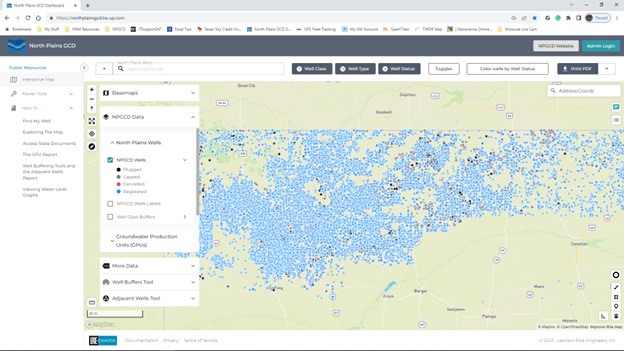
It’s Here, It’s Here!
The long-awaited NEW interactive map is now available! After nearly a year of working with the map contractor, LRE Water of Denver, Colorado, the district’s interactive map is up and running.
The new map contains tools and features not available in previous versions of the map. It also includes links to other databases; Texas Water Development Board well data, County Appraisal Districts, and map features showing state boundary layers. Viewers can see major and minor aquifer boundaries and watershed data. Property owners can create reports on their wells such as classification, status, pumping capacity, and other data. The map has tools for helping property owners map locations for possible new well sites and spacing. There are videos provided in the help section on how to use the tools and features, along with a video exploring the map for new or first-time users.
Additionally, users can view logs from the district files in the same manner as the district’s old map. Please be aware that not all well logs will be available. Wells drilled before coming into the district may not have associated logs. Users can navigate to the groundwater interactive map through the district’s website here. Questions concerning aquifer conditions or the interactive map can be directed to Odell Ward, oward@northplainsgcd.org.